Moshulatubbee District on:
[Wikipedia]
[Google]
[Amazon]
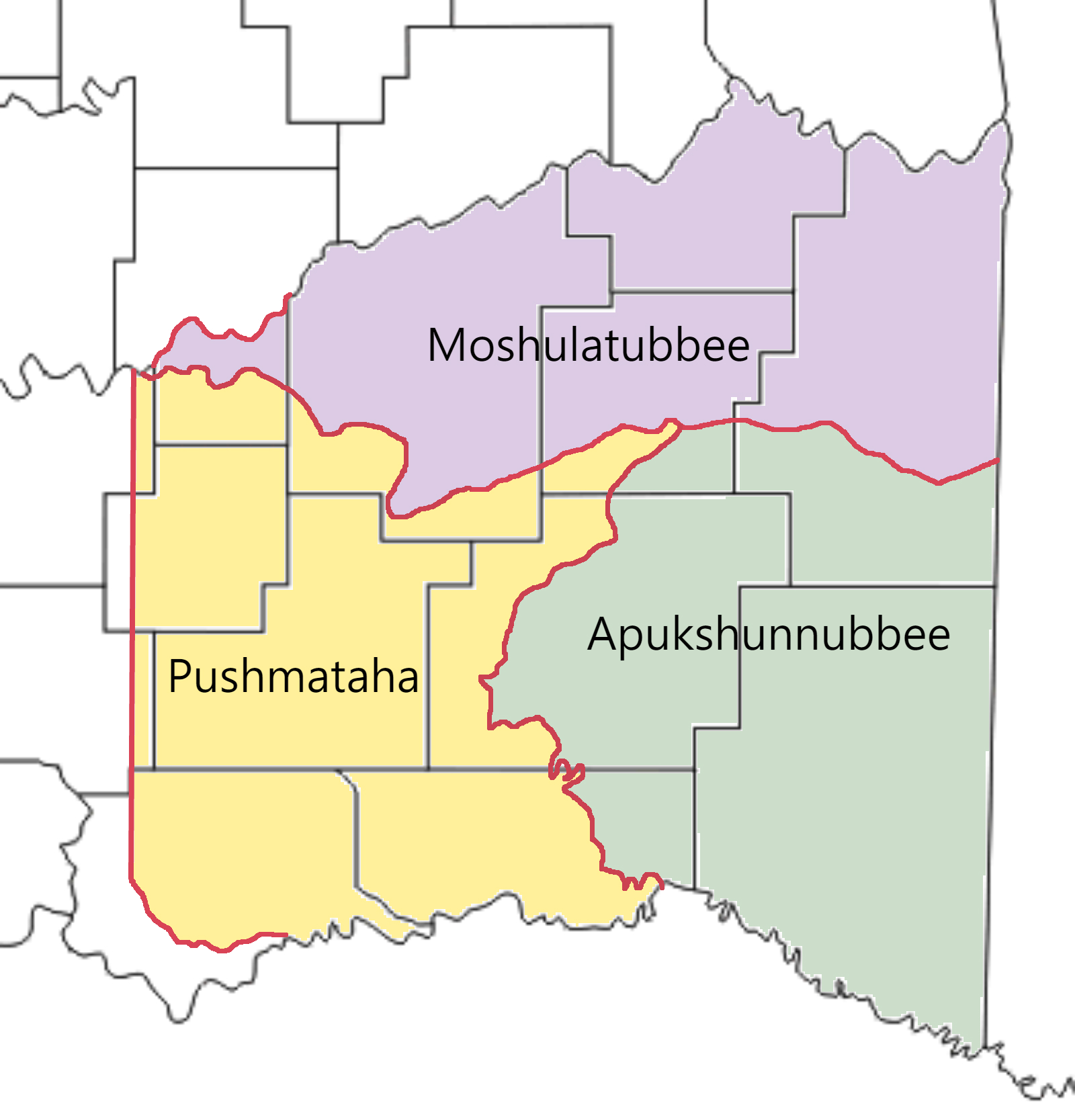
Moshulatubbee District was one of three administrative super-regions comprising the former
 The districts were established when the Choctaw Nation removed to the
Choctaw Nation
The Choctaw Nation ( Choctaw: ''Chahta Okla'') is a Native American territory covering about , occupying portions of southeastern Oklahoma in the United States. The Choctaw Nation is the third-largest federally recognized tribe in the United ...
in the Indian Territory
The Indian Territory and the Indian Territories are terms that generally described an evolving land area set aside by the Federal government of the United States, United States Government for the relocation of Native Americans in the United St ...
. Also called the First District, it encompassed the northern one-third of the nation. In some historic records it is spelled Mushulatubbe.
The Moshulatubbee District was named in honor of Chief Moshulatubbee, a Choctaw Indian warrior and statesman. Moshulatubbee was chief of the ''Okla Tannap'' ("Lower Towns") District in the original Choctaw Nation of the Southeast. Many Choctaw from that period referred to the Moshulatubbee District as the Okla Tannap District. The other two districts were known as Apukshunnubbee and Pushmataha
Pushmataha (c. 1764 – December 24, 1824; also spelled Pooshawattaha, Pooshamallaha, or Poosha Matthaw), the "Indian General", was one of the three regional chiefs of the major divisions of the Choctaw in the 19th century. Many historians cons ...
, also named after important leaders.
History
 The districts were established when the Choctaw Nation removed to the
 Indian Territory
The Indian Territory and the Indian Territories are terms that generally described an evolving land area set aside by the Federal government of the United States, United States Government for the relocation of Native Americans in the United St ...
. These districts were intended as areas for members of the three major clans
A clan is a group of people united by actual or perceived kinship
and descent. Even if lineage details are unknown, clans may claim descent from founding member or apical ancestor. Clans, in indigenous societies, tend to be endogamous, meaning ...
, or groupings of Choctaw who comprised the nation. In time, the clan affiliations and allegiances were reduced after the disruption of the move to Indian Territory, in part because of the losses of numerous members in the arduous relocation, called the Trail of Tears. The districts’ importance in the political life of the nation waned, and the district chiefs lost power and authority to the governor (under the 1858 constitution) and later, the principal chief of the nation. Eventually the position of the principal chief became simply, the chief. No longer a "first among equals", he became the sole political leader.
In judicial affairs, the three districts and their seats of government retained their historic influence. Most crimes within the tribal jurisdiction were tried at the county level. If they were of a certain category, they were tried automatically at the district level. Court days were the busiest days of the year in the district seats of government.
Moshulatubbee District’s administrative seat of government was Gaines Court House. This also served as the county seat of Gaines County. The court house was northeast of modern-day McAlester, Oklahoma
McAlester is the county seat of Pittsburg County, Oklahoma, Pittsburg County, Oklahoma. The population was 18,363 at the time of the 2010 census, a 3.4 percent increase from 17,783 at the 2000 census,Shuller, Thurman"McAlester" profile ''Encyclop ...
.
Included in the Moshulatubbee District were the Choctaw counties of Gaines, Sans Bois, Skullyville, Sugar Loaf, and Tobucksy.
As Oklahoma's statehood loomed in the early 20th century, the Moshulatubbee District, and its constituent counties, slowly wound down their governmental functions. The United States Courts in the Indian Territory usurped their powers. On November 16, 1907, Oklahoma’s Statehood Day, the districts and their counties disappeared as active jurisdictions.
The territory of the former Moshulatubbee District is incorporated principally into the present-day Oklahoma counties of Haskell
Haskell () is a general-purpose, statically-typed, purely functional programming language with type inference and lazy evaluation. Designed for teaching, research and industrial applications, Haskell has pioneered a number of programming lan ...
, Hughes
Hughes may refer to:
People
* Hughes (surname)
* Hughes (given name)
Places Antarctica
* Hughes Range (Antarctica), Ross Dependency
* Mount Hughes, Oates Land
* Hughes Basin, Oates Land
* Hughes Bay, Graham Land
* Hughes Bluff, Victoria La ...
, Latimer, Le Flore, and Pittsburg.John W. Morris, ''Historical Atlas of Oklahoma'', plate 38.
References
{{reflist Choctaw Indian Territory Pre-statehood history of Oklahoma 1907 disestablishments